
The image gallery is at the bottom of the page
We paddled the entire length of Sognefjorden over five days i July 2015. Sognefjorden in western Norway is the world’s longest open fjord with a total length of 185 kilometres before meeting the coastline with its larger islands. Two fjords in Greenland and Antarctica are longer geologically, but covered with glaciers and icecaps. In several places Sognefjorden is up to 5 kilometres wide and we followed the northern shore, as this is the better option when considering currents and tidewater.
The fjord landscape is the result of glacial eroding during several ice ages when the ice was scraping along the valleys already created by running water, thus creating the landscape we see today.
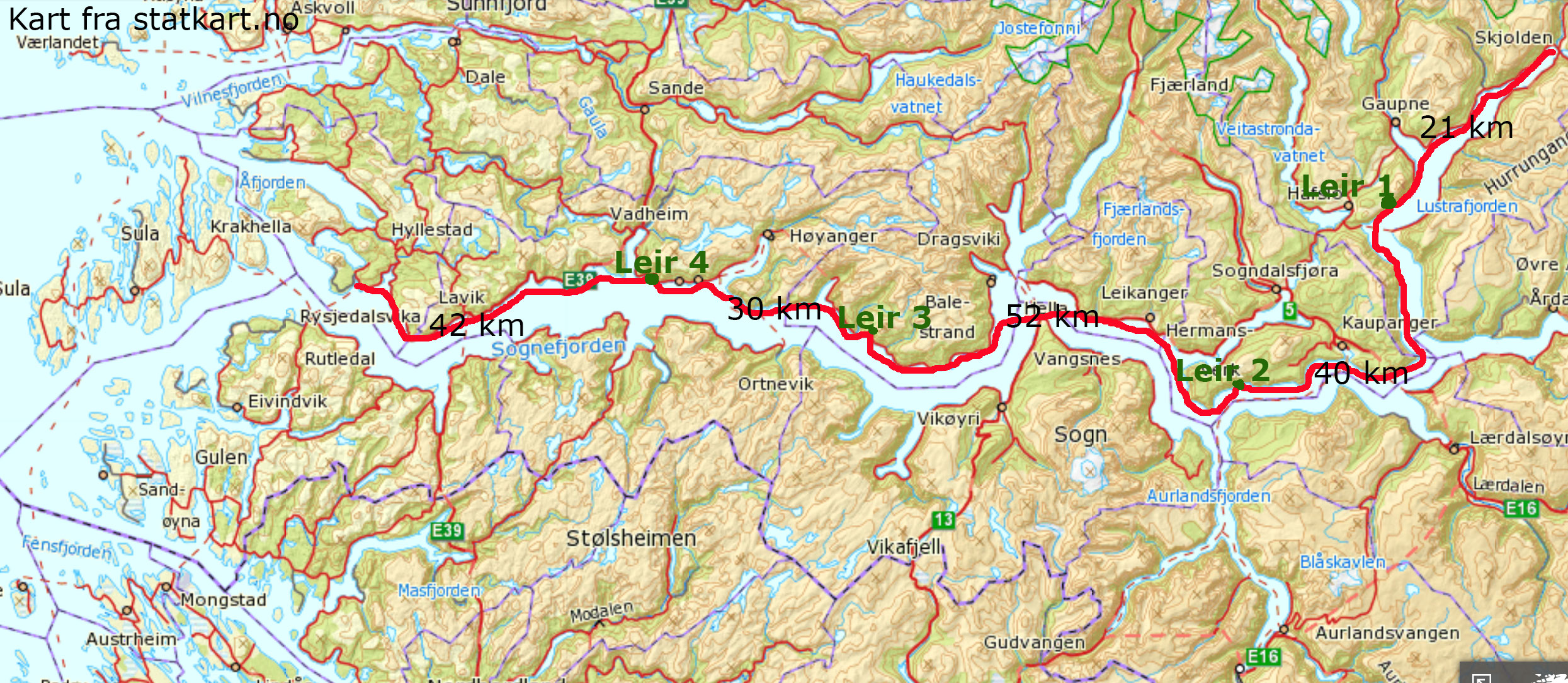
The map shows the route and campsites (click to enlarge – “Leir” means “campsite”).
Follow this link to an interactive map from the Norwegian mapping authority. Scale, and switch between land map, nautical map as well as aerial photo.
The following description must be read bearing in mind that we paddled into variable headwinds the entire length of the fjord.
We started out from Skjolden on a calm Monday afternoon in July and finished in Rysjedalsvika before midday on Friday. The forecast was low pressure, wind on the coast and calmer in the fjord. As wind, waves and handheld cameras are somewhat incompatible – the images below are shot in periods with calm conditions.
We experienced variable winds, sometimes very strong as the wind came whistling out of the side-fjords (arms) and as vertical wind down valleys and mountain faces. These winds were hard to predict and changed fast. In parts of the fjord there is up to 40 kilometres of fjord surface and thus great opportunities for waves to form even in low winds. Combined with long stretches of cliff-shores it left us feel quite exposed in places. We ended up paddling at night the last leg to take advantage of the calmer conditions, as the short Nordic summer-nights allows for this. The wind often catches up before every headland and slows down a bit after. In general we experienced that the wind followed the main fjord in the inner and outer parts, and was more unpredictable in the mid-section of the route.
On the first day we left Skjolden in dead calm conditions, but we soon ran into force 5 to 6 headwinds and choppy waves created by wind meeting the currents on its way out. We landed our kayaks on the beach of the Luster camping site and sat out the windy conditions, before heading for our first campsite. The second day we experienced both headwind and calmer conditions. A generally calm third day allowed for 52 kilometres of padling that day. On the fourth day it was windy and exposed at times, and we had to land our kayaks in the early afternoon after 30 kilometres, as the wind round the headlands was too strong to make any progress. We slept through the afternoon and evening and finished off the trip the fifth day with a 42 kilometres night to morning paddle in a gentle headwind.
The fjord offers varied scenery and landing and campsite conditions in the different sections of the fjord. The Lustrafjorden part of the fjord offers several good campsites and many spots to land the kayaks in case of emergency. While the inner parts of Lustrafjorden are populated, the southern part of Lustrafjorden is desolate with no roads and few farms or huts. The next 20 kilometres is the start of the main fjord and is exposed with rock walls and gullies with rock fall debris right into the fjord. There is however the possibility to escape at the ferry-quay at Manheller after 10 kilometres.
After passing the Amlabukti and westwards until crossing over to Leikanger there are many possible campsites and a somewhat more gentle shore. Leikanger is populated and the shore is occupied with buildings and marinas. When crossing over to the Balestrand area via the Vangsnes headland on the south shore, the shoreline is predominantly sloping water and ice swept rock faces. This is the case for most of the central section of the fjord. There are few good campsites and suitable landing spots are few and far between.
The same clean rock-faced shoreline is also dominating the outer section of the fjord, but here there is a more diverse shoreline with some sheltered small coves and small rocky beaches.
For large parts of the fjord the road is close, but nearly always out of sight from the water.
We finished our fjord paddle in Rysjedalsvika where the boat routes Bergen to Nordfjord and Bergen to Sogn meet.
A trip like «Sognefjorden – full length» can easily turn into a run for speed and efficiency. But if you have, and take, the time there are lots of places and fjord arms to explore. Along our route on the north shore we could have:
– visited the Lustrabui bakery in Luster
– spent a night on the beautiful camping/caravan site in the same village
– visited the immensely beautiful village of Solvorn with the old Walaker hotel
– crossed over to the Urnes headland and visited the old stave church.
– stopped by the Amlabuki (cove)
– made a two day paddle in/out Fjærlandsfjorden to the Mundal village with its «city of books» and an old hotel.
– maybe visited the village of Balestrand with its long and prominent tourist traditions, wooden buildings and an old hotel.
Moving over to the south shore you will find the world heritage area of Aurladsfjorden and Nærøyfjorden, as well as smaller fjord arms as the beautiful Arnafjorden, Finden and Finnabotn.


